The Raleigh Naturalist

June 29, 2008

Lake Raleigh and Arnie’s latest project

Filed under: Southwest Raleigh — Tags: , — raleighnaturalist @ 8:20 pm

This post was originally published on Feb 10, 2008.

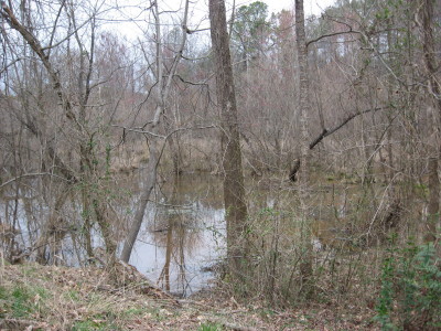
A great blue heron soars above Lake Raleigh, pictured below. Enjoy these images and then steel yourself: for myself, Russell B., Tom P. and many others, the content of this post is tragic. Places I took my children, I will never show theirs.

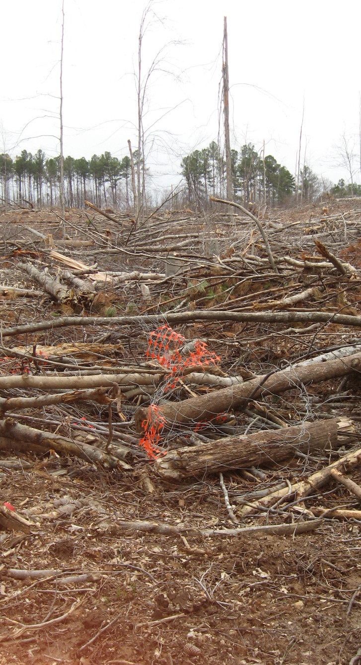
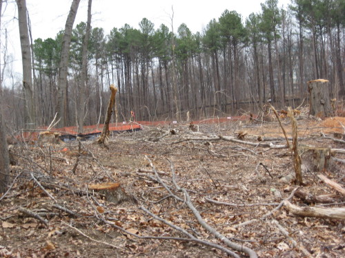
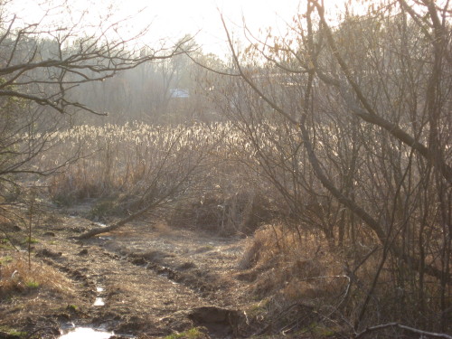
The loss of these hillsides, beloved by Raleigh trampers of the non-path, searched (and reportedly sown) by generations of NCSU botanists, studied by students, studded with rich diverse plant and animal populations: this is surely a greater loss in terms of pure ecology than any other Raleigh landscape changes I can think of recently. I know the red clay pictures are unfair, I know the sign (legible if you click on my picture) explains that this will be a model “green” golf course and a lab for NCSU environmental designers (just like the one they are building at the coast just for Basnight!) I even accept that most of these scenes were covered with fairly scrubby trees and was historically cultivated, and that the golf course will offer lots of pluses for wildlife. I was relieved to see the study area still intact on the lake hillside that also contains the new President’s house and Alumni House. But even after the golf course, they are not nearly done building here. Hopefully below is the low spot and it all gets better from here! But I’m sad. Arnold Palmer is designing the course – it’s bound to be pretty traditional design when push comes to shove. Good luck to the foxes! Not much hope for the deer. But then, we’ve got too many of them anyway 😦

see all my golf construction pics

Lake Raleigh photo tour

later post with pics of completed course

February 26, 2008

Atlantic Ave. and Hodges Road – industrial greenway (draft title)

Filed under: Central Raleigh, Greenways & Parks — Tags: , — raleighnaturalist @ 11:47 pm


Joe Miller’s recent column about the “bandit trails on the northeast section of the greenway expresses justified shock at the denuding of these hillsides right next to the greenway.  His concern is the trail bikers, whose magnificent structures are only hinted at in my  only pictures before their destruction.  I am sorry I didn’t photo more – I always felt a little guilty about creating evidence against them.  But now I wish their death-defying ravine crossing were documented.  Maybe, somewhere, they are.

But the larger picture surrounding this greenway is just about as fascinating…Longbranch, steep hillside engineering project ( under repair), the rock that turns Crabtree…and the shocking side by side shots of the winter view from the greenway then and now

http://blogs.newsobserver.com/joemiller/index.php?title=atlantic_avenue_trails_r_i_p&more=1&c=1&tb=1&pb=1

Final post as it appeared on Raleigh Rature’s 1st url.

published March 6, 2008

Bike Trails RIP highlights greenway loss


     The destruction of the bike trails described by Joe Miller is not just significant for these bandit bikers: all users of the greenway between Atlantic Avenue and Capital Boulevard should mourn the loss of this old farm site, whose naked hillsides (and future clapboard townhouses) are easily visible from the greenway. Riparian buffer is the term for the ecological value of these wooded areas contiguous with the greenway:  the trees absorb rain as well as pollution, shade and cool the waters of Crabtree.  Of course, the wildlife appreciates wooded areas next to the creek as well.

     This is a rich and variegated section of greenway with lots of interesting features in addition to the old farm site.  If you park off Capital Blvd. at its intersection with Yonkers Road, you will have to jump the barrier that tells you this problematic section of greenway deck needs shoring up (since repaired).  The risk seems minimal, and I’ve done it many times.  From this deck you can see the naked hillsides, and then follow that section of greenway as it heads toward Atlantic Avenue.

view of Joe Miller's "mohawk look" from greenway

view of Joe Miller's "mohawk look" from greenway

view from end of Six Forks

view from end of Six Forks

      All is not lost.  Below is a lovely path that begins at the base of the hillside deck and heads straight toward the southbound ramp off the beltline for Capital Boulevard.  If this stretch survives the development, that will be significant for this greenway section.


From the west end of the dramatically steep but problematic deck, you are looking toward Atlantic Avenue.  This stretch parallels Hodges Road and looks across Crabtree at the old site for the State Farmer’s Market.  Below you see a bog visible to the right of this stretch, and the cattail marsh between it and Atlantic.  This marsh has not kept its water – aside from the drought – since greenway construction occurred at its feed into Crabtree.  It is quickly becoming a scrub meadow.

January 21, 2008

The Volkswagen boulders and winter findings

Filed under: East Raleigh, Greenways & Parks, Nature Lore — Tags: , , , — raleighnaturalist @ 3:47 am

At Buckeye Trail’s beginning there is a strange hill hump meadow thing that looks very out of place.  It is an old rather small landfill that must have served Raleigh a very long time ago, but recently enough to be mowed and monitored as landfills now must be.  It swells at the base of a ridge coming down from Peartree Lane across Milburnie Road into the Crabtree floodplain and diverts the waters coming down from Longview Lake into a deeply carved creek that parallels Milburnie and strikes Crabtree just north of the Bow Tie Club, where a very dubiously placed parking lot has been scraped out right next to the creek and seemingly in the water’s right of way.  Anyway, this landfill meadow hides a local kids’ landmark on its wooded northern slope: two huge boulders that must have been unearthed in the landfill’s operation. I mean huge! You know how big they are? Check the title!

 They sit in the middle of this woods in east Raleigh like alien monoliths. There just are no big rocks in this part of Raleigh – it’s either red clay or sand, but no rocks.  Before the greenway got built, I would go every few winters and make a ritual of being able to locate, once again, these well hidden icons of my childhood woodcraft.  Now, the cross-country trail which begins at the top of the landfill meadow takes me down the ridge to a spot where I can hop off and find them in minutes.   Which is cool, and I still go.  But only in winter.  There are large number of sewer line cuts and various off-trail adventures which poison ivy forbids from me most of the year.  But in the dead of winter, I can explore these spots with impunity – as long as I don’t grab any vines while hopping ditches!

***********

 This stretch of greenway shows Crabtree slowing down and deepening as it winds through the marshy joining with Marsh Creek.  The quiet stretch below is just before turning at Milburnie to slide under New Bern Avenue and curve with the beltline toward the Neuse River junction at Anderson Point.  Another touchstone on this walk (available at all times of year, right next to the greenway) is the largest oak gall of which I know.  These red bugs (and I mean true bugs for those in the know) come swarming out of it dangerously early in the spring some years.

There are all kinds of nifty finds on this easternmost stretch of greenway.  Below are two interesting types of fungi: shelf mushrooms and slime mold.

January 18, 2008

Yates Mill Ponderings

Filed under: Greenways & Parks, Nature Lore, Raleigh History, Raleigh mills, Southwest Raleigh — Tags: , , — raleighnaturalist @ 2:03 am

The park at Yates Mill Pond is in the purview of this blog – just over a mile from the beltline – but partakes of rural Raleigh and Raleigh history in a profound way that few other sites in that purview do.  The watershed, the mill history, the flood history, the facility and its wonderful homage to all of the previous: here is a nature experience with, truly, something for everyone.  The new center has marvelous open beam vaulted ceilings  and huge window walls that look out on the pond – you feel like you’re in a Biltmore hunting lodge. There is a large set of multi-media displays that give a rich sense of the mill’s multi-family, multi-disaster history.  Back outside, the fishing deck is usually in use, but there are lots of private corners of the pond to explore.

 Walk past the fishing deck and you have a choice of directions to begin a large loop: to the right you can explore a the wet meadow valley around a ridge from the main pond.This trail winds around by NCSU research farmland and then up the ridge to the Penny Road side of the facility.  Currently hurricane damage has closed the connecting segment, so that you are diverted back across the fishing deck to return to the center.

update 6-09 – all 3 trails are open

If you go left after the fishing deck, you are following a trail right beside the pond with twenty specimens of trees, labeled with numbers to go with a brochure available in the center.  There is lots of wildlife, such as the skink seen below. A great place we will return to soon!

Below, from a historical image is my drawing in The Natural History of Raleigh.
Yates Mill Pond


January 11, 2008

Oh, my! Here we go – and hawks in Cameron Village!

Filed under: About & reflection, Central Raleigh, Nature Lore — Tags: , — raleighnaturalist @ 1:07 am

This first “normal” post is late –  my own natural history took a sudden gust last Saturday when the huge spread in the News & Observer began a cascade of calls, messages and e-mails about everything from binding family Bibles to studio tours.  Wonderful, but hairy – and all I want to do is get back to the red-tailed hawk family who has moved into Cameron Village.  These guys are swooping down to roost sometimes right beside the library and the one on the left below looks like a juvenile.  I’ll start a series of observations and let you know.  We see these guys all the time – whereas you need to get near some flowing water and real country to see the slightly smaller red-shouldered hawk.


December 31, 2007

Welcome to The Natural History of Raleigh

 fall-on-the-west-beltline_1_1_1.jpg

Fall on the Beltline at Jones Franklin

*************

Our trees, almost without exception, show the succession process at work, with loblolly pines taking over abandoned land, maples and dogwoods peeking out from under as they age, and hardwoods like oak, hickory and tulip tree slowly rising out of the aging pines as disease and self-pruning clears the way.  This stand on the southwest corner of the beltline exemplifies this science idea and is also a “purty sight” – a common dual theme of this blog.  Look around, check back for weekly posts – thanks for coming!

************ 

The welcome rain this holiday has filled (and muddied) area waterways.  in case you didn’t know it, quite a few sections of greenway flood temporarily on a regular basis.  Under Atlantic Avenue, between Centennial and S. Saunders, and west of Raleigh Swamp are just a few areas where mud will usually reign until the city bobcats come scraping through.  The re-shoring of the greenway deck off Capital Boulevard is still keeping that steeply edged section closed. Joe Miller wrote an excellent recent update on Greenway projects here.

photos of Crabtree creek levels after recent rains

**********

« Newer PostsOlder Posts »

Blog at WordPress.com.