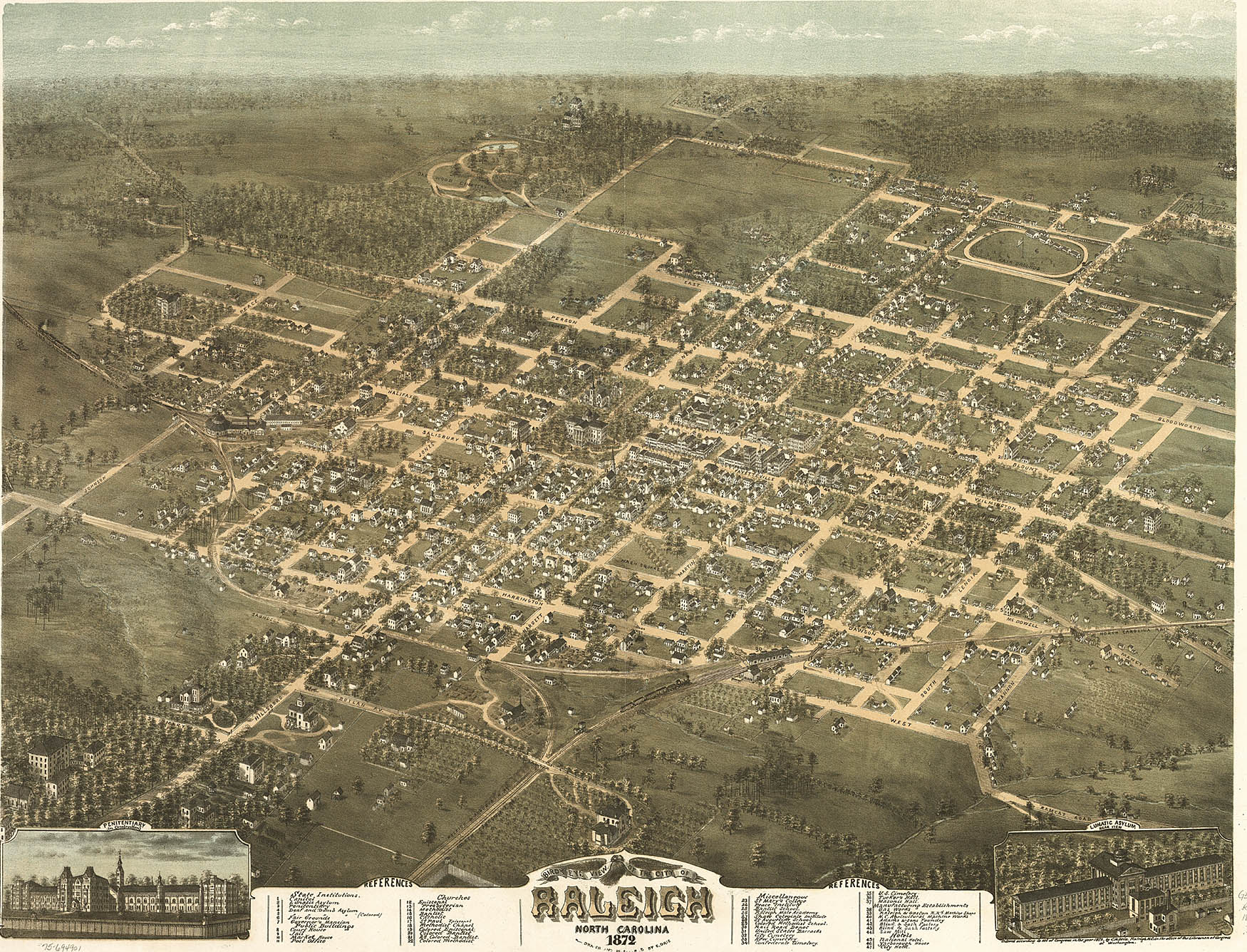
Raleigh in 1872
Raleigh is, of course, an invented city. Planned in advance at a tavern somewhere between Litchford and Falls of the Neuse, drawn in regular squares, purchased from Joel Lane for about $3 an acre, 400 acres of the one thousand purchased were divided and sold in lots to the prominent families who expected to inhabit it, with five large squares reserved for community purposes. It is reminiscient of D.C. in its ordered squares and patterns of street names, but nevertheless a fairly typical large Southern town in many respects, with a seasoning of “cow-path roads” to leaven those squares. The early city expanded its boundaries in 1857, avoided destruction in 1865, and then then expanded again in 1907 with some of the South’s first “suburbs,” – serviced by trolley lines! Hayes Barton, named for the deer-filled English homeland of Sir Walter, was a prime example. Raleigh’s growth went straight north for many decades after that, but has recently expanded in lots of directions -though not evenly. Rural scenes can still be had with just a few minutes driving going south or especially east.
**********
Crabtree Creek dominates Raleigh geography, just as it does this blog. It drains a huge swath of land across Wake County. Its head waters are in west Cary and it empties into the Neuse at Anderson Point just off US 64 East. In between, it makes a slow northward curve that defined the Beltline right of way with useless lowlands, then slopes southward to its union with the Neuse. If Crabtree stayed full, it would be a river itself, and it often outdoes the Neuse in flow after heavy rains. But ours is a low flow water system with periodic normal droughts. Crabtree often barely moves through the huge ditches it has carved into the sediments of lowland Raleigh. When it roars, it scours these floodplains with a muddy concoction of tree trunks, lumber and flotsam that can dress the landscape in astonishing sights. Thus the cheap right-of-way. But no more! Stores on huge slabs of fill dirt, townhouses on stilts, rich slopeside houses with mandatory first floor basements – Raleigh has embraced the floodplains. And Crabtree has been ditched and channeled, dammed and diverted to save the shopping center. Walnut Creek’s much smaller but intricate watershed drains the southern half of the city. And Swift Creek below that flows through and forms some of the most fascinating wildlife areas in the Triangle.
************
Water is what maps an area. We get ours from Falls Lake, due north, and return the treated waste water to the Neuse southeast of here. Crabtree and Walnut Creek wrap around the high ground of downtown and North Hills like bow legs, reaching the river just a couple of miles apart. Our waterways have gained the dual importance of riparian buffer and wildlife habitat, and the parks and greenways map right on to the waterways with few exceptions. A map of wildlife inside the beltline might as well be a map of the creeks. So that is where this blog will tend to find itself – streamside.


