The Raleigh Naturalist

February 14, 2019

Raleigh Swamp Recovers from a Swamping

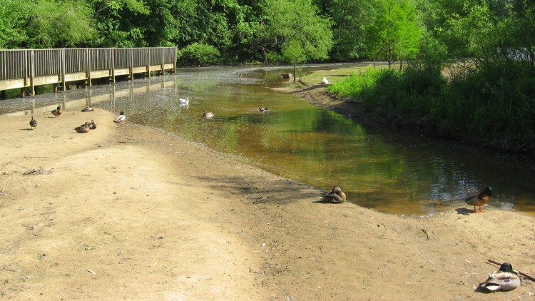
Raleigh Swamp is a prominent, even dramatic feature of the Raleigh Greenway at the intersection of Crabtree Boulevard and Raleigh Boulevard, joining Buckeye Trail to Middle Crabtree Trail and crossing a large shallow body of water with a causeway. The water was never intended to be permanent, but a wetland was turned into a shallow lake by the work of beavers, as explained in this 2013 post.

The place is a paradise for visiting birds, thirsty deer and other wildlife, and an amazing collection of turtles that bask by the piled up dozens on the many logs protruding from the water. The causeway was built with best ecological practices, minimizing disruption, but it has needed repairs recently because of extensive flooding. Cara and I visited in November 2018 and saw some of the work.

The crossing of the greenway with a utility cut has been strengthened and guarded with metal gates. The northwestern end of the site has a short stretch of asphalt that has repeatedly been ruined as the flooded marsh cuts through the shoulder of Crabtree and dumps excess water into the creek. looks like they are going to repair (instead of culvert) it once again, but this spot has closed the causeway, officially that is, for months. Most people just make their way around the mild barricades.

Different species of trees can tolerate shorter or longer periods of flooding. Ash, river birch and of course willows can survive many weeks of inundation. But if flooding lasts too long, trees die and the vegetative regime changes.

This area was a scrubby wetland with a smattering of drier tussocks and paths through it until the construction of the Raleigh Boulevard bridge. Many relics of the former trees dot the wide expanse of water. There is thus a small justiofication for the term used by locals and myself, Raleigh Swamp, though in fact this is a marsh. Whatever you call it, it’s a great place to bike walk, fish, or bird watch.

Below is the illustration I created from the lead photograph for my new book, the Natural History of Raleigh. Raleigh Swamp is featured in Chapter Four.  Happy trails!

The Natural History of Raleigh


May 20, 2015

Raleigh Nature Starts a Shift Westward With Lake Lynn Residency

Filed under: About & reflection, Nature Lore, Rural Raleigh, waterways, West Raleigh — Tags: , , , , , — raleighnaturalist @ 7:25 pm
A red-throated loon shows his Springtime stuff at Lake Lynn  in northwest Raleigh

A cormorant shows his Springtime stuff at Lake Lynn in northwest Raleigh

Blog News June 2015
This blog always centered on a book project: The Natural History of Raleigh, which now exists as a finished manuscript of 25,000 words I am working to get published. Having retired from over twenty years as a special educator, my wife Cara and I are selling our Oakwood home and moving to Asheville, setting up book arts studios as well as a big garden and small greenhouse to grow food, papermaking fibers, and flowers. For Cara’s final year of teaching, we are renting a small apartment that overlooks Lake Lynn. The blog will eventually take on a state-wide perspective, but will always focus on urban natural areas and have plenty of posts about Raleigh. For now, enjoy the Lake Lynn and Falls Lake areas I will pop into when in Raleigh, while I explore and document what to show you up in Baird Cove.  Best,  John
Sliders at Lake Lynn

Many kinds of wildlife inhabit Lake Lynn, but (for enthusiasts) it has a citywide reputation for its turtles.

Lake Lynn, along with Shelley Lake, was created to provide flood protection to Crabtree Valley Mall, which was constructed in a former muddy cow pasture and flooded soon after it was built. Hare Snipe Creek, which feeds Lake Lynn, runs from the back of Tabernacle Church on Leesville nearly due south all the way to Crabtree by the Golden Corral headquarters on Glenwood Avenue. Lake Lynn has a gigantic earthen dam but is normally quite shallow, and its edges are dissected by the numerous small creeks and freshets that formerly found their way to Hare Snipe Creek. A popular greenway with long boardwalks encircles the Lake, and a spur follows the soggy wetlands of its headwaters up to a public park. At uncrowded times (and I’m talking people driving and parking at my apartment complex just to walk here) it’s an opportunity for some remarkable encounters with nature.

ducks

Some of the more interesting  birds to watch are naturalized escapees – dark, red-wattled Muscovy ducks and aggressive white barnyard geese. Lake Lynn itself is a mixture of native and natural features blended with the man-made lake and the surrounding (relatively wooded) apartments and houses. The Canada geese, well described in an earlier post, are so numerous and boisterous as to evoke aquatic chickens as they honk out the rising day outside our windows each morning.

 An Enticing Nearby Area

Cypress trees on the southwestern shore of Falls Lake

Cypress trees on the southwestern shore of Falls Lake

Just a few miles north of Lake Lynn I can cross over the highest spot in Wake County – Crestmont off Leesville Road – and travel out of Crabtree Creek’s watershed into that of the Neuse, inundated by Falls Lake. North of 98, off Baptist Road, is an access point for the Mountain-to-Sea Trail, which traces the southern shore of Fall Lake. Here a juncture of powerline cuts and shallow lobes of the lake provide wide open views and a nifty look at a population of cypress. There is a stunning serpentine boardwalk that serves the trail, and a raised bridge over Lick Creek with gorgeous views. More to come, as well as more on the whole stretch from here to the Rollingview Marina.

Lick Creek footbridge

cypress in Falls Lake

April 9, 2013

Raleigh Swamp Shifts with Sewer Project

sewer project meets Raleigh Swamp_1_1

The huge sewer project – seen above at Crabtree Boulevard looking toward the Mouth of Pigeon House Branch – has introduced a new geography to Raleigh Swamp, my name for the body of water off Raleigh Boulevard just north of its intersection with Crabtree Boulevard.  The large wooden causeway and gazebo were wonderful additions to the meeting of Buckeye trail and Middle Crabtree Trail.  Now the sewer project has dictated a large dam and concrete bridge section that bisects the “swamp.”  I know a real swamp is moving water with trees, but this lowland was dotted with dying trees for years after its establishment, and the snags of many remain as resting spots for herons, cormorants, and the occasional wood duck.  Canada geese and mallards breed here, while the turtle population has grown to a staggering level.  It is all thanks to the beavers.

Raleigh Swamp_1_1

When I first returned to Raleigh from Greensboro in 1980, they were starting to build the Raleigh Boulevard bridge over Crabtree Creek.  The caissons they used to sink the bridge piers were impressive, and Dulci, my black lab and I kept a close watch on the process.  At this time, the “Raleigh Swamp” area was a sometime wetland dotted with scrub trees and ribboned with the paths of homeless campers. Like many floodplains in the area, it got wet in the winter but stayed dry most summers.  The Boulevard project changed that, with a little help from the local beavers.  The transition was clarified for me by a city engineer years later through a comment on this blog in 2009.  I quote it in full below:

Was reading through your website after getting the link from the Fletcher Park Watergarden and noted that the “pond” off Raleigh Blvd was one of your favorite places. I thought I’d mention that this was actually a City of Raleigh mitigation project I designed many years ago to offset the environmental impacts from the construction of Raleigh Blvd. It was supposed to be a wetland but the beavers in the area had a different idea as they immediately blocked the culverts under the roadway causing the water to back up and form a permanent pond. Can’t say I object to the result of their efforts. It’s a beautiful spot and the addition of the greenway has made it accessible to the masses.

Mark Senior, PE, Senior Project Engineer, Water Quality Section, Stormwater Divsion of the City of Raleigh Public Works Department

The beavers have indeed made great use of the spot with several different lodges in different spots.  New generations of beavers tend to build their own lodge. Until I got the info from Mark, I assumed the construction of the road bed dammed up the water.  The water on the east side of Raleigh Boulevard acts more normally – rising and falling with rains and seasons.  I know the beavers play over there as well, because you can see their slides into Crabtree Creek as you walk down Buckeye toward Rollingwood.

Raleigh Swamp sewer dam_1_1

sewer pipe dam looking toward Crabtree_1_1

sewer dam bridge on causeway_1_1

Getting back to the sewer project, you can see above the large dam across the wetland.  This, along with the upgraded line in general, has changed the location and depth of water around the edges of the marsh (which is technically what it is).  Some areas are now totally dry – at least for now – and some are substantially deeper.  No real harm done, since nature and time effect these kinds of changes all the time anyway.  but the newly dry areas, which were beaver playgrounds until now, will undergo an interesting and specialized kind of succession – new plants adapted to the new conditions will take over.   It should be a fascinating transition and Raleigh Nature will keep an eye on it.  Below are shots of the stranded areas.

dry area behind sewer dam_1_1dry wetland near stairs of causeway_1_1new dry area at Raleigh Swamp_1_1

The beavers had a lodge at the very spot pictured below years ago but abandoned it during the drought of the early 2000s.  Perhaps they will rebuild now that the water situation is restored!

former beaver lodge water restored!_1_1

All posts on Raleigh Swamp

previous post on this sewer project

June 29, 2008

Hot Spring Critter Sightings!

Filed under: Central Raleigh, Greenways & Parks, Nature Lore — Tags: , , , , , — raleighnaturalist @ 11:12 pm

This post was originally published in May 2008

This owl swooped down and landed on a branch directly above Crabtree Creek as I walked on the high greenway that traverses a steep hill off Capital Boulevard.  This is just east of the sad section that has recently had its woody buffer appropriated by bulldozers.

 It sat there for the 20 minutes or so I watched it from different angles.  I believe it’s a Barn Owl.  This was about half hour before dusk.  The owl was getting ready for work.

The owl is somewhere in the scene below.  Crabtree takes a sharp bend as it approaches Capital Boulevard near the beltline.  It is turned by a large rock outcrop that underlies the hill on which a large former car dealership resides, framed by the south ramp off the beltline.  The slope from the back of the car dealership down to the creek is some really interesting terrain, and the troublesome but dramatic walkway that clings to the hillside is one of my favorite stretches in the whole system. One reason being it’s a great place to spot turtles, as you will see below. (snapper story below that)

Below is the rock that turns Crabtree.  It looks dark and foliated, but it’s drenched in algae, so Iwon’t make a specific guess.


 ***********

Snapper Lays Eggs

The family of one of my students had a female snapping turtle crawl up into a sandy area near their backyard creek and lay some eggs.  She finished and went on  back to the creek, and now they get to watch for babies.  Good luck to Carson and her family!


December 28, 2007

Raleigh Swamp – Great Nature AT the Beltline

    Raleigh Swamp is the local nickname for this expanse off Raleigh Boulevard. A massive boardwalk with gazebo connects Buckeye Trail with Capital Boulevard.  There are almost always blue herons and/or hawks, dozens of various turtle species, the occasional thirsty deer, and the best chance I know to actually see beavers during the day.  Raleigh Boulevard has become their permanent no-maintenence dam, but their two houses – one on the west bank near the railroad and one right beside the boardwalk – have been badly exposed by the drought.  We will return here often.

Raleigh Swamp Photo Tour

Google map of area linked below:

View Larger Map

Crowder Park on Ten-ten

Filed under: Greenways & Parks, Nature Lore, Rural Raleigh — Tags: , , — raleighnaturalist @ 4:39 pm

 State Road Number 1010 is a very old country road that runs from Highway 50 in Garner to Apex, east to west below Lake Wheeler.  Southwest of Lake Wheeler on Ten-Ten is a relatively new county park. Doris Crowder donated land in 1992, but with a setback from Hurricane Fran, the facility did not open to the public until 1998.  The public nature amenity seems slightly out of place in this relatively bucolic setting, but the houses are going up fast and it probably won’t be that way long.  There are paved walkways around the 2.7 acre pond pictured above, and there are structures for picnics and summer programs.  You really get the feeling looking out into the woods that if you struck out on your own, you would soon meet country dogs or perhaps a chicken house.  Below are some cardinal flowers and other denizens of the pond.

crowder-park-mallards_1_12

Older Posts »

Create a free website or blog at WordPress.com.