The Raleigh Naturalist

April 18, 2011

Nature Knocks Downtown Raleigh

Filed under: Central Raleigh, Gems & Surprises, Nature Lore, Raleigh History, South Raleigh — Tags: , , — raleighnaturalist @ 7:00 pm

piece of Memorial Auditorium roof with damage visible right background

A tornado or series of tornadoes accompanied a quick moving spring storm on Saturday afternoon, April 16th and left a trail of death and destruction across Raleigh, mostly south and east of downtown. Farther north, pine trees crashed into a mobile home at Stonybrook off Brentwood Road and instantly killed three young boys. There were 21 fatalities across the state, and Shaw University closed down for the semester with widespread damage. Raleigh Public Record has a big portfolio of images, as does NandO, and WRAL has a gallery as well – but what I want to see is a track record of these powerful winds, which sheared off trees 50 yards from my house and caused widespread lasting damage. I hope to update this post with more meteorology info later. Below are my images – mainly of the venerable oaks toppled and pruned in City Cemetery and elsewhere downtown.

closer look at Memorial Auditorium damage

City Cemetery at New Bern and East Street

cropped cedar in City Cemetery


The entrance to City Cemetery on New Bern Avenue.  A comment on Goodnight Raleigh’s photos mentiones the extensive damage from here to Tarboro Road.  Clearly the damage was overwhelming and Sunday morning it was amazing to see unattended damage, unpoliced intersections with no stoplights, and downed lines with no crews in sight.  I fully realize they had their hands full elsewhere.

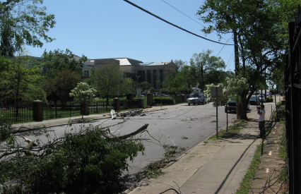
New Bern Avenue closed by tornado damage

New Bern avenue family surveys damage

Martin and East Street downtown

South East Street after tornado

damage at corner of Moore Square

touring the tornado damage Sunday April 17

Blount and South Street after 4-16-11 tornado

damage at Shaw and Memorial Auditorium

cropped trees in Shaw's practice field

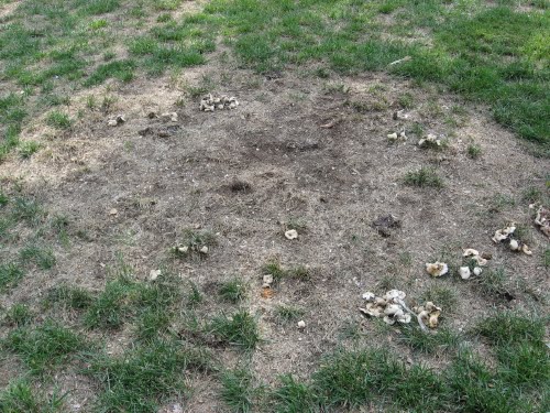
uplifted turf in southeast downtown Raleigh

I have another whole set of pictures from the Maywood Street area between S. Saunders and Lake Wheeler Road.  I’ll post them soon with updates on the scientific measure of this storm, which may have generated as many as 8 tornadoes, some at least F3 in scale.  Hope you all are well!

September 16, 2010

Mushroom Madness

Filed under: Central Raleigh, Nature Lore, North Raleigh — Tags: — raleighnaturalist @ 3:13 am

Heavy (though quite sporadic) rains have brought a veritable plethora of mushrooms this summer. Below is a taste – the whole set of them is over on the Natural History of Raleigh Photos.

These twin babies, found in Cedar Hills Park, might get much bigger.  Check out the grapefruit sized monster below, which was part of a faerie ring at my school, The Fletcher Academy.

North Carolina’s Piedmont and Coastal Plain boasts over fifty species of mushrooms, according to the Duke Mycology page.  I would not begin to identify positively any of these, but they are fun to examine and track as they release their spores and decay.

The shelf or turkey-tail mushrooms above are also from Cedar Hills Park, contiguous with the TFA campus and often visited by “Mr. DJ” and his students.  Below is an ancient, algae encrusted shelf mushroom from the other end of my life’s spectrum – the parking lot at Sadlacks!

The faeries must have had a wild time in THIS circle.  Found in the Capitol Square in downtown Raleigh.  A reminder: mushrooms form these circles because the parent organism, consisting of thousands of intertwined undergound threads, has a central core and radiates outward in all directions.  The mushrooms we see are the spore-producing “fruits” of that organism.

Mushroom photo album

Duke photo site for NC Mushrooms

July 2008 Mushroom post

August 9, 2010

Marsh Creek Park – no relation to the creek!

My Google search hits revealed someone looking for Marsh Creek Park, and having featured the creek, I thought we should visit the recently expanded park on New Hope  Road.  The name of the park derives from Marsh Creek Road, which begins just across New Hope and goes straight down to Marsh Creek.  But New Hope Road is a ridge between the Crabtree and Neuse watersheds, and the waterways in the park itself- mostly out of sight without hiking – head north through a large woodlot visible from Southall Road toward the Neuse, just a mile distant.

All pictures click to enlarge

The hot new feature in the park is the skate park, which was featured in a several media articles and is quite popular.  The large recreational center is fairly nondescript, but was constructed with green principles, as described in detail (along with other park amenities) at Get To Know a Park.  Beside the center is a large Piedmont prairie, and the extensive parking areas are adjoined by interesting ecotone areas, though the stilt grass is spreading fast.  The terrain is typical of Piedmont farmland after 50-60 years – upland pines and chestnut oaks with a slope down to loblollies, shrubs, and water.


My favorite find at Marsh Creek Park was the rain garden just below the skate park, with a wonderful stand of Joe-Pye-weed, as seen below.  I’ve only seen this handsome plant in the mountains, but it is listed in the Piedmont.  Somebody did a great job with this rain garden.

 To make the park’s name issue a little stranger, there is a really nice marshy area below the lower field, which leads to a very pretty old farm pond. It appears to have a fishing shack on the edge.  The expansion doubled the usable space of the park, but most of the acreage is still heavily wooded and ripe for exploring.  Overall, a versatile park with something for everyone.

photo album of Marsh Creek Park

Google map of Marsh Creek Park

*************************

This section of Raleigh – the ridge of New Hope with the valley of the Neuse to the northeast and Marsh Creek’s drainage to the southwest – is of geologic interest because it is one of the transitions between the Piedmont and the Coastal Plain.  If you take Buffalo Road off New Hope, for example, you immediately start seeing sandy soils.  Just down the road from Marsh Creek Park, Skycrest Drive heads down to good old Raleigh Swamp.  Before it gets there, at the intersection with Trawick, you can find this meadow of wildflowers.  It is being sorely threatened by kudzu vines.  We will keep a closer eye on invasive species in our future nature travels.

The kudzu is right behind the dandelions.

An impressive array of wildflowers fronts the dandelions by a slope.

These blackberry flowers are beside Skycrest. This was in May, but this summer I picked almost ten quarts of these things!  They are everywhere.

Kudzu making its way toward the wildflowers.

Kudzu go’ne eat us all!!

April 12, 2010

Pigeon House Re-Hab Project Helps Edna Metz Wells Park

A wonderful piece of graffiti has garnered some media attention for the stream restoration project along Smallwood Drive just below Cameron Village.  Cameron Village was the first shopping center in the Southeast, and when Willie York built it he diverted, ditched and straightened the headswaters of Pigeon House Branch, which gather between Cameron Village and the Raleigh Apartments.  The creek takes a straight shot right under Clarke Avenue into Edna Metz Wells Park, and after heavy rains the water, which gathers from a large section of the Oberlin Road ridge of Civil War fame, would roar through the tiny park, eroding and scouring and backwashing debris into the tributary water piped down from the glade along Forest Street above the park.  The City of Raleigh is working on a general rehabilitation plan for Pigeon House Branch, and the Smallwood project, which is pretty much finished, is part of that.  Apparently they are going to remove some invasive species before doing final plantings, both on Smallwood and in Edna Metz, in the fall.

From the main approach, the park looks beseiged..  But as you will see below, in the interior, all is well.  This spot is a real haven in Central Raleigh, and was a mainstay for my young children and me in the nineties.

 The Smallwood St. project involved using large boulders and some nice terraces to slow down and complicate the path of the water.


The media interest, started by a nice post from Goodnight, Raleigh, centers on a graffiti portrait of Edie Sedgewick, Andy Warhol’s muse, painted on the culvert where Pigeon House enters Edna Metz.  My picture of the scene is below.

Josh Shaffer called me and asked about the construction and Ena Metz, but never specifically mentioned the graffiti.  I’m pretty sure they won’t scrape it off as part of the re-hab project, but I can’t really say for sure.  Hope not.  It is indeed a nice harmless piece of art.  The figure says “De,” which is the word for power in Taoist philosophy.  I appreciate Josh’s feature of it and the park, as well as his kind words for my work.  And thanks as always to John Morris and his compadres over at another of Raleigh’s “splendid blogs!”

Goodnight ,Raleigh post on Edna Metz Wells Park

photo album of Edna Metz and Smallwood project


to buy the book based on this blog, click below

The Natural History of Raleigh

February 13, 2010

Snowy Tree Blocks Buckeye Greenway

Downed Tree on Buckeye Trail in East Raleigh Blocks Snowy Greenway

High winds on top of rains toppled quite a few trees in the area, including this pair of medium specimens lying across the Buckeye Trail greenway at the bottom of Suicide Hill, as it was labeled by the cross country runners who used the greenway before its recent upgrade.  Lowered grade, I should say, since the cruelest, steepest stretch was lengthened and terraced to bring this oldest section of greenway into national codes.  Suicide Hill climbs a rugged quartz and sandstone outcrop that forms the Rocky Overhang, one of the seminal pillars of this blog, as it represents my favorite Crabtree hangout.

Raleigh Nature’s  “scoop” on this downed tree is wonderfully fitting as I get back to basics after a bit of hiatus. Enamored of the Ken Burns series, engulfed by teaching responsibilities, and constantly lured by my current intellectual fling, Ray Johnson/Black Mountain/mail art, I have wintered in the blog a bit, but could not resist the lovely, harmless 3 inch fluff that ended on a Saturday morning.  So I took off for my favorite sight-seeing greenway, Buckeye Trail from Milburnie Road. At the edge of Rollingwood, Crabtree has carved out a tall bluff (at least for this part of Raleigh) and under this 40 foot hump the creek has gouged a fishing hole complete with overhanging boulder shelves from which to cast.  Drowning worms  and hauling up the occasional catfish or bream at the Rocky Overhang is a family tradition for me as child and parent.  Heck, I took dates there, I loved the place so much. I was slightly horrified the day soon after Hurricane Floyd came through to see that a very large sycamore tree across the creek had fallen directly onto the Rocky Overhang, and for several years it was too tangled to get down there.  The kids and I mourned but also learned some valuable lessons about how Crabtree changes over time.  Now that tree has finally eased its way mostly into the fishing hole (after forming a hideous litter trap for more than a year on the way in) and the boulders have cleared somewhat.  In the spring, we’ll take a look, but for now here are more snowy scenes from Buckeye Trail, a gall tale, and a link to the photo album from my snow walk.


The baby beeches we have admired before looked nice mixed into the snowy pines.  Below is the scene at the beginning of Buckeye, where Longview Branch parallels Milburnie as it slides into Crabtree.


Below is a  ditched brook that brings water from the slopes of Rollingwood under the greenway and into Longview Branch just before it reaches the creek.

Just off  Milburnie is the old landfill that now forms a rich meadow, a favorite browsing place of the numerous deer living in Crabtree’s floodplains in East Raleigh. 

Below are some deer and coon tracks in the February snow.

The stump of a large oak I miss very much looked just as sad in the beautiful snow.  This tree had the largest gall I ever saw – a triple-grapefruit sized lump that housed the larvae of box elder beetles.  Greenway maintenence brought it down – I doubt the gall was a factor, but I’ve wondered.

the oak gall

Photo Album of my snow walk


December 8, 2009

Lassiter Mill Shows Crabtree at Strength


 The previous post talked about Crabtree Creek’s tendency to flood – last week again brought heavy rains over the Crabtree watershed that brought the creek up to the edge of  its large channels.  This also sends an impressive load of water over Lassiter Mill Dam, as seen above.  I shot a video clip of the rushing water from below the tailrace, as linked below.

video- Lassiter Mill dam at high water

What happens at Lassiter Mill vividily and intensely demonstrates what happens lots of places more gradually – the deposition of new soil by spreading flood waters.  This is an essential part of the natural systems of the Piedmont, and our flood control measures prevent the process from periodically enriching the soil with a layer of mud and silt – though the process continues to work just fine in the “waste” lowlands that remain in Raleigh.  An astounding number of these lowlands have become major thoroughfares – roads built relatively later in Raleigh’s long history, on land left undeveloped due to the floodplain.  The Beltline follows the low contours of Walnut Creek, House Creek, Crabtree Creek, Big Branch, Marsh Creek and then Walnut Creek quite precisely as it curves from Cary’s Buck Jones to Glenwood, over the crest of North Hills, and around southeast to Poole Rd and then Lake Wheeler Road.  The water is piped and rushed away from underneath these elevated roadways, carrying its minerals with it.

The suburbs and businesses near these roads certainly don’t need the sediments!  But the stuff has to go somewhere, and these days there is a lot of stuff.  When streams are buffered by a healthy band of water-loving trees and shrubs, erosion material is reduced greatly. In central Raleigh, Crabtree is clogged with lots of dislodged soil, construction materials and unnaturally exposed red clay.   But the deposition process is a vital one, and it gets exaggerated at Lassiter Mill, where the water brings its load of suspended minerals hurtling over the dam and then slows and spreads its course below.  As it slows, it drops much of its sediment load.  The area below Lassiter Mill changes yearly as the creek alternately erodes and builds up materials.  Check out the new load of sand deposited by the recent high waters.

There are several caveats and complications to consider.  This is a large load of sand!  Eight or nine inches at a dose, and not the silt and mud that the plants would prefer. But nature adapts, and the Lassiter “beach” is fun to browse, with a wide variety of weeds incubated from the loads of  soil and debris.  The silt and sand that currently washes down Crabtree is terribly unhealthy for the filtering mussels and other delicate aquatic life.  The red clay that paints Crabtree brown is such a strong pigment that Crabtree often changes the color of the Neuse where it conjoins.

Crabtree builds itself “shoulders”  as it repeatedly overflows, dropping the heaviest particles first as the water disperse into the floodplain.  This is why Crabtree presents such a tall ditched appearance as above at Hodge Road.  The plants arrange themselves in an orderly sequence beside or on top of these embankments according to their tolerance for flooding.

The next time Crabtree rises over it’s banks, put on your rubber boots and check out the glistening mica-rich silt that covers the greenways before the city sends its scrapers to clear it off to the side, where it enriches the plants as well as any landscaper’s mulch.  You are walking in the stuff that makes our floodplain soils, a rich muck delivered by the yearly floods.

Nature.org floodplain info

BBC floodplain story


« Newer PostsOlder Posts »

Blog at WordPress.com.