Straight Streets is a category for posts that sketch toward an essay (as do most posts on this blog) about Raleigh streets that can tell a story in their sequence. Martin Street, Hammond/Person/Atlantic, and Hillsborough Street are all obvious candidates. What follows below will activate the category for now, but I will return to Six Forks again, I’m sure.
*************
Longbranch to Falls: Six Forks Low to High

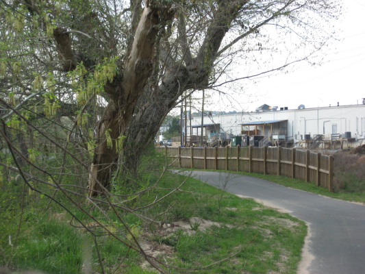
Six Forks dead ends right into Crabtree Creek on the south, and dead-ends right into Fall Lake northward. Along the way it takes you from Crabtree’s muddiest, most ditch-like stretch to a state park. Above is the best spot on the tour – an upper tributary of Shelley lake just off Six Forks at the northern top of the greenway (aside from 2 isolated sections at Lake Lynn and Durant Park). Below is a fairly ironic juxtaposition (a theme of this blog) – the back of the Longbranch saloon, edged by the greenway.
From a parking spot at the plumbing supply at Atlantic Avenue and Hodges Road, you can hop on to the greenway, or you can stop at the southern dead-end and check out the dried-up wetland parallel to Atlantic. The map below shows the area – don’t forget to try the satellite view! Also, an image of the southern dead-end is below that.
Map of Briggs Hardware:919-832-2025 2533 Atlantic Ave Raleigh, NC 27604, US

This end of Six Forks boasts a Bojangles, Briggs, and a townhouse development that began the process of replacing an old creekside farm with development. The doomed wooded hillsides are currently used by guerilla mountain bikers for amazing and terrifying structures (more on that another post- the site is edged by the greenway). Just behind Briggs you can check out a nice outcrop of Raleigh gneiss. As you start driving north on Six Forks, you pass through Raleigh’s second-most famous floodplain – the old K-Mart used to flood every ten years or so, and the car dealerships still move their entire stock uphill after threatening rains. With the super Kroger’s on your left, you cross Big Branch just before it joins Crabtree behind Southern States. Upstream of this spot, Big Branch carves away the southernmost “North Hill” with a vengeance, creating a soil profile that represents thousands of years of accretion.
************
At the top of the hill is the beltline crossing and North Hills, including Mr. Kane’s new project. You have left central Raleigh (and the floodplain) and entered former farmlands. The soil is clay, the houses used to be exclusive, but have been superceded to the north and west, and are fairly diverse in value and inhabitants. Small parks dot the neighborhoods, and traffic is horrible on weekdays. Beyond North Hills, you are in the heart of Raleigh’s steady northward population shift. There are some atrocities and some gems (again, we will return to this Straight Street soon). For now we will end with a treat just north of 540 – an old-fashioned country gas-n-deli with 200 kinds of wine and live bait! A reason to love living in Raleigh, indeed. Six Forks used to go right up to Creedmoor, but now dead-ends into the Falls Lake State Park administrative facility. We will come back to this complex sequence soon.
a photo tour of Six Forks Road


 Edna Metz is a wonderful urban amenity tucked into Cameron park just below Cameron Village shopping center. It boasts unusual and large short-leaf pines, my record tulip tree inside the beltline, and a mountain-like atmosphere right after a rain, as the two small creeks climb down rocks before joining and starting down Johnson Street toward Pigeon House Creek downtown. Tiny but complex, its steep hillside is dotted with escaped daffodils in the spring, and the dense tree cover and intertwining creeks make each area seem separate and private.


