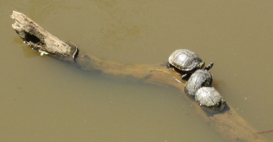
T urtles have been an obsession for a long time. The contemplative stare of a turtle can really make you think. Time I spend around them is time connected to prehistory.

Jaycee Parks’ lily garden is a treasure of heirloom varieties nestled in one of the prettiest natural areas inside the beltline. Many, many varieties and a beautiful nature walk to go alongside. The small creek travels over a couple of significant waterfalls and creates deep pools where large dace minnows live. This park is being seriously threatened by kudzu, encroaching from the south into the upland mix of post oak and northern red oak. The path that winds around the fairly steep hillside feeds right into a fascinating section of greenway – it follows directly behind some backyards and then follows Gardner up to the Rose Garden.

 Raleigh Swamp hawk & Snapper. One is free. I hope the other one is happy. Who can say?
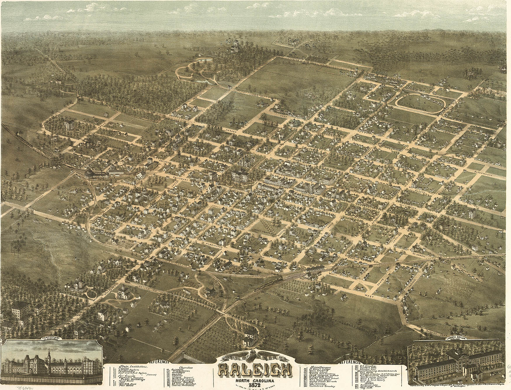
Raleigh is, of course, an invented city. Planned in advance at a tavern somewhere between Litchford and Falls of the Neuse, drawn in regular squares, purchased from Joel Lane for about $3 an acre, 400 acres of the one thousand purchased were divided and sold in lots to the prominent families who expected to inhabit it, with five large squares reserved for community purposes. It is reminiscient of D.C. in its ordered squares and patterns of street names, but nevertheless a fairly typical large Southern town in many respects, with a seasoning of “cow-path roads” to leaven those squares. The early city expanded its boundaries in 1857, avoided destruction in 1865, and then then expanded again in 1907 with some of the South’s first “suburbs,” – serviced by trolley lines! Hayes Barton, named for the deer-filled English homeland of Sir Walter, was a prime example. Raleigh’s growth went straight north for many decades after that, but has recently expanded in lots of directions -though not evenly. Rural scenes can still be had with just a few minutes driving going south or especially east.
**********
Crabtree Creek dominates Raleigh geography, just as it does this blog. It drains a huge swath of land across Wake County. Its head waters are in west Cary and it empties into the Neuse at Anderson Point just off US 64 East. In between, it makes a slow northward curve that defined the Beltline right of way with useless lowlands, then slopes southward to its union with the Neuse. If Crabtree stayed full, it would be a river itself, and it often outdoes the Neuse in flow after heavy rains. But ours is a low flow water system with periodic normal droughts. Crabtree often barely moves through the huge ditches it has carved into the sediments of lowland Raleigh. When it roars, it scours these floodplains with a muddy concoction of tree trunks, lumber and flotsam that can dress the landscape in astonishing sights. Thus the cheap right-of-way. But no more! Stores on huge slabs of fill dirt, townhouses on stilts, rich slopeside houses with mandatory first floor basements – Raleigh has embraced the floodplains. And Crabtree has been ditched and channeled, dammed and diverted to save the shopping center. Walnut Creek’s much smaller but intricate watershed drains the southern half of the city. And Swift Creek below that flows through and forms some of the most fascinating wildlife areas in the Triangle.
************
Water is what maps an area. We get ours from Falls Lake, due north, and return the treated waste water to the Neuse southeast of here. Crabtree and Walnut Creek wrap around the high ground of downtown and North Hills like bow legs, reaching the river just a couple of miles apart. Our waterways have gained the dual importance of riparian buffer and wildlife habitat, and the parks and greenways map right on to the waterways with few exceptions. A map of wildlife inside the beltline might as well be a map of the creeks. So that is where this blog will tend to find itself – streamside.


This is the section of Crabtree my friend Bob Bryant and I used to run to straight after school in fifth grade. We’d carve letters in the big beech that overhung the last big ravine before the creek, and slide down the same bank troughs as the beavers did at night. This was the sixties and that section of Crabtree marked the city limit. My Dad had brought me here first, 6 blocks from our house at the east edge of Raleigh, showed me the beeches and the rocky overhang, and promised death if I ever tried to cross the water. That admonishment lasted quite some time, but became a motivating taboo later. We played hard down on Crabtree, shot BBs, hauled in catfish and literally dreamed of what lay beyond the muddy banks that were then the city limit of Raleigh. On a nostalgic walk during early college years, I was astonished to see a construction project plowing through our old haunts. They had started work on the Raleigh Greenway.
***********
Buckeye Trail is the oldest section of the greenway, running from Milburnie Road near Wake Med, upstream to Crabtree’s intersection with Capital Boulevard at the old Farmer’s Market. It is considered the “birdiest” section by the Wake County Birders. For example, I (no birder myself) have see all three of the woodpeckers likely to be seen – red-breasted, red-headed, and the crow-sized pileated – on this two and one-half mile walk. Below is the eastern beginning of the greenway – an old Raleigh landfill turned into a meadow – great place for seeing deer at dusk.


The Natural History of Raleigh

Raleigh lies at the edge of the Piedmont, edging the eastward coastal plain with long ridges of ancient, deformed and partly rotted granite called the Raleigh Belt on geology maps. Tucked into these ridges are gnarled streamcut valleys and occasional domes of harder, younger granite that have withstood the slow erosion of the Piedmont “peneplain” – the huge flattened wedge of material washed down over millions of years from the formerly towering Appalachian mountains. The topographical features of the Piedmont are not pushed or folded up, but instead cut into this gently sloping plateau by the slow relentless action of water. “Our landscape … deepens”, says Michael Godfrey in the bible of Piedmont naturalism. In Raleigh, this process has created a broad rippled dome that shoulders down to the beginnings of the Coastal Plain. The gently rolling hills of clay to our west and north represent a very different landscape from the sandy flats just to our south and east.
***********
I learned this topography bicycling around central Raleigh ( which, in the late fifties and early sixties, was all the Raleigh there was). I experienced this topography gravitationally and intuitively. As a teenager I discovered that downtown sat on a flattened dome, so that if I got a good start in the parking lot of Tabernacle Baptist Church on Person Street, I could ride all the way home from choir practice no hands, nearly all the way going downhill to my suburb at the edge of Crabtree Creek’s floodplain in East Raleigh. As a young child in this neighborhood, I has already fallen in love with Crabtree Creek, which along with Walnut Creek to the south, carves and shapes Raleigh’s lowlands. Crabtree became a strong symbol in my life, framing a big chunk of my childhood memories and haunting my early bad poetry.
***********
Now as an adult I find the city has paved and bridged all of my childhood creek haunts and more, providing a greenway system that maps the waterways and helps defend a buffer of streamside woods that is the final refuge for an astounding variety of wildlife and botanical wonders. These gar, coons, deer, turtles and woodpeckers eke out a co-existence with an emerging mid-sized city. Raleigh wants and tries so hard to be a “real” city, with all that implies. Yet it retains some of the best features of a Southern town, not least of which is close proximity to authentic rural landscape. And one of the best and most-promoted urban features is the park and greenway system. With much continued support, this resource can assure us of a unique place in the hierarchy of national destinations. Join me to explore Raleigh’s parks, greenways, and other natural areas. I promise you will be impressed by the sights and nature lore to be found inside the beltline or within a mile of it.
***********


 go to Natural History of Raleigh Photos


