The Raleigh Naturalist

May 11, 2019

Mountain Meadow Flowers

Filed under: Exotica, Gems & Surprises, Western NC — Tags: — raleighnaturalist @ 2:26 pm


Asheville from Lookout Mountain

My retirement town has many great views, but the best one of downtown is from the hillside beside the UNC-A observatory on Lookout Mountain. (The campus is visible middle right). This southern-facing meadow is rich with spring flowers right now, and most of these species are to be seen in Raleigh as well.

The daisies erupt from a sea of green. This hillside gets mowed maybe once a year to keep out the trees and shrubs. So all the herbaceous plants fight it out.

The mix here is rich and includes Virginia creeper and occasionally poison ivy. It is regularly used by hikers and dog walkers.

The plants below don’t make pretty flowers, but we might remember bending the stem around and shooting their little brown fruits at each other. This is a nice stand of plantain, a highly useful herb which can make poultices and other medicinals.

Mullein plants

Mullein plants make a fine tea and don’t flower until late summer, but man, that flower is a phallic wonder! An amazingly tall green thrust cover with tiny yellow petals.

This aster has already flowered and is ready to set it’s seeds sailing in the wind. Every plant has its own rhythm.

The walk up to the view of downtown Asheville is short but strenuous, well worth the effort on an early spring morning to see the profusion of blooms.

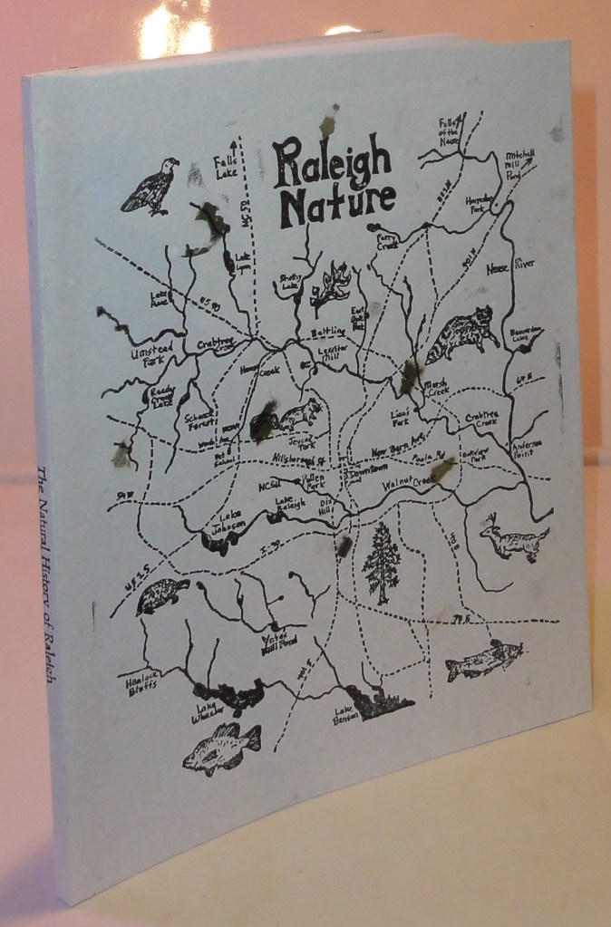
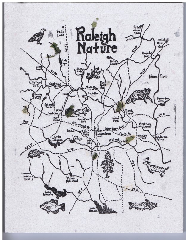
An early feature on Raleigh spring flowers can be found here. If you haven’t done so, please check out the new book based on this blog!

The Natural History of Raleigh


Advertisement

February 14, 2019

Raleigh Swamp Recovers from a Swamping

Raleigh Swamp is a prominent, even dramatic feature of the Raleigh Greenway at the intersection of Crabtree Boulevard and Raleigh Boulevard, joining Buckeye Trail to Middle Crabtree Trail and crossing a large shallow body of water with a causeway. The water was never intended to be permanent, but a wetland was turned into a shallow lake by the work of beavers, as explained in this 2013 post.

The place is a paradise for visiting birds, thirsty deer and other wildlife, and an amazing collection of turtles that bask by the piled up dozens on the many logs protruding from the water. The causeway was built with best ecological practices, minimizing disruption, but it has needed repairs recently because of extensive flooding. Cara and I visited in November 2018 and saw some of the work.

The crossing of the greenway with a utility cut has been strengthened and guarded with metal gates. The northwestern end of the site has a short stretch of asphalt that has repeatedly been ruined as the flooded marsh cuts through the shoulder of Crabtree and dumps excess water into the creek. looks like they are going to repair (instead of culvert) it once again, but this spot has closed the causeway, officially that is, for months. Most people just make their way around the mild barricades.

Different species of trees can tolerate shorter or longer periods of flooding. Ash, river birch and of course willows can survive many weeks of inundation. But if flooding lasts too long, trees die and the vegetative regime changes.

This area was a scrubby wetland with a smattering of drier tussocks and paths through it until the construction of the Raleigh Boulevard bridge. Many relics of the former trees dot the wide expanse of water. There is thus a small justiofication for the term used by locals and myself, Raleigh Swamp, though in fact this is a marsh. Whatever you call it, it’s a great place to bike walk, fish, or bird watch.

Below is the illustration I created from the lead photograph for my new book, the Natural History of Raleigh. Raleigh Swamp is featured in Chapter Four.  Happy trails!

The Natural History of Raleigh


January 10, 2019

Lassiter Mill – Most Searched and Commented Post

Lassiter Mill illustration from John Dancy-Jones’ book The Natural History of Raleigh

Lassiter Mill and Raleigh Mill History is by far the most popular post on this blog, with “Lassiter Mill” the biggest search term. That early post has served as a magnet for people looking for information and stories about Raleigh Nature. And the comments on that post, found here, are an amazing collection of memories, from jumping off the bridge to family picnics, from shad runs to visiting Mary Lassiter at her store beside the old mill. Plus local history from a descendant of Issac Hunter! The comments are featured in my newly published book, and have helped it become quite popular at Quail Ridge Books, which is now located just a mile up the hill from Lassiter Mill.

The Natural History of Raleigh

16 chapters, 30 illustrations conveying the sights, nature lore and history of Raleigh’s natural areas and greenways

November 15, 2018

The Natural History of Raleigh is published!!

Filed under: About & reflection, Gems & Surprises, Nature Lore — Tags: , , — raleighnaturalist @ 5:06 pm

I am so proud to share that the book I have been working on for over a decade, for which I started this blog, is in print at last. Published by my own press The Paper Plant, it is an 80 page book with 16 chapters and 30 illustrations that captures the best of what i have learned and seen concerning Raleigh NC’s wonderful greenway system, parks, and other natural areas. This blog has been crucial in developing the book, and several features relate directly to the blog, especially the fantastic comments on Lassiter Mill and it’s history posted on the blog. Thanks to all my Raleigh Nature readers and I hope you obtain and enjoy the book.

cover is hand-laid paper with block print

select illustrations

order through The Paper Plant

order through Amazon

Also available at Quail Ridge Books and So&So Books in Raleigh

May 20, 2015

Raleigh Nature Starts a Shift Westward With Lake Lynn Residency

Filed under: About & reflection, Nature Lore, Rural Raleigh, waterways, West Raleigh — Tags: , , , , , — raleighnaturalist @ 7:25 pm
A red-throated loon shows his Springtime stuff at Lake Lynn  in northwest Raleigh

A cormorant shows his Springtime stuff at Lake Lynn in northwest Raleigh

Blog News June 2015
This blog always centered on a book project: The Natural History of Raleigh, which now exists as a finished manuscript of 25,000 words I am working to get published. Having retired from over twenty years as a special educator, my wife Cara and I are selling our Oakwood home and moving to Asheville, setting up book arts studios as well as a big garden and small greenhouse to grow food, papermaking fibers, and flowers. For Cara’s final year of teaching, we are renting a small apartment that overlooks Lake Lynn. The blog will eventually take on a state-wide perspective, but will always focus on urban natural areas and have plenty of posts about Raleigh. For now, enjoy the Lake Lynn and Falls Lake areas I will pop into when in Raleigh, while I explore and document what to show you up in Baird Cove.  Best,  John
Sliders at Lake Lynn

Many kinds of wildlife inhabit Lake Lynn, but (for enthusiasts) it has a citywide reputation for its turtles.

Lake Lynn, along with Shelley Lake, was created to provide flood protection to Crabtree Valley Mall, which was constructed in a former muddy cow pasture and flooded soon after it was built. Hare Snipe Creek, which feeds Lake Lynn, runs from the back of Tabernacle Church on Leesville nearly due south all the way to Crabtree by the Golden Corral headquarters on Glenwood Avenue. Lake Lynn has a gigantic earthen dam but is normally quite shallow, and its edges are dissected by the numerous small creeks and freshets that formerly found their way to Hare Snipe Creek. A popular greenway with long boardwalks encircles the Lake, and a spur follows the soggy wetlands of its headwaters up to a public park. At uncrowded times (and I’m talking people driving and parking at my apartment complex just to walk here) it’s an opportunity for some remarkable encounters with nature.

ducks

Some of the more interesting  birds to watch are naturalized escapees – dark, red-wattled Muscovy ducks and aggressive white barnyard geese. Lake Lynn itself is a mixture of native and natural features blended with the man-made lake and the surrounding (relatively wooded) apartments and houses. The Canada geese, well described in an earlier post, are so numerous and boisterous as to evoke aquatic chickens as they honk out the rising day outside our windows each morning.

 An Enticing Nearby Area

Cypress trees on the southwestern shore of Falls Lake

Cypress trees on the southwestern shore of Falls Lake

Just a few miles north of Lake Lynn I can cross over the highest spot in Wake County – Crestmont off Leesville Road – and travel out of Crabtree Creek’s watershed into that of the Neuse, inundated by Falls Lake. North of 98, off Baptist Road, is an access point for the Mountain-to-Sea Trail, which traces the southern shore of Fall Lake. Here a juncture of powerline cuts and shallow lobes of the lake provide wide open views and a nifty look at a population of cypress. There is a stunning serpentine boardwalk that serves the trail, and a raised bridge over Lick Creek with gorgeous views. More to come, as well as more on the whole stretch from here to the Rollingview Marina.

Lick Creek footbridge

cypress in Falls Lake

January 26, 2015

Anderson Point Anchors the Union of Crabtree and the Neuse

moss mountains by Crabtree

moss on a rock outcrop by lower Crabtree Creek

Crabtree is usually a low-flow creek, but after long and heavy rains, its flow can rival the Neuse River, of which it is a major tributary. The newly completed lower Crabtree Trail, featured in my previous post, provides a very long bridge that gives you a good sense of Crabtree’s large size as it approaches Anderson Point to flow into the Neuse.

Crabtree bridge at Anderson

Crabtree begins in Cary and after passing though Morrisville and Umstead Park, arcs across north Raleigh, roughly parallel to 440. It gathers water from Brier Creek in the north to downtown Cary in the south: a huge swath of Wake County’s terrain. As it approaches Anderson Point Park, it is large and wide.

Crabtree Trail crosses the creek at Anderson Point

Crabtree Trail crosses the creek at Anderson Point

Anderson Point Park is a large complex amenity. Off Rogers Lane (from New Bern Avenue or New Hope Road) you can park before the bridge over the 64 bypass to access the Neuse River Trail and canoe put-in, or cross the bridge into the park proper, where large fields, picnic shelters, and specialty gardens attract many local families. At the bottom of this large and open expanse, a wooded path leads to the confluence of Crabtree and the Neuse. The connector with the Crabtree Trail is back at the top of the slope.

Crabtree Trail at Anderson

Following this path northward from the park, one gets a great sense of Crabtree’s lower floodplain forests. Large beeches are profuse, and American holly greens up the dark stands of winter sweetgum and ash.

beech on lower Crabtree Trail

American holly in Crabtree's floodplain

American holly in Crabtree’s floodplain

The ancient age of Crabtree can be inferred from sandstone outcrops – huge rocks built by the creek itself over eons. Just before the creek crosses under Rogers Lane, it crosses over flat sheets of even older, harder rock and is only a few inches deep in times of low water. On the day of this visit, the water was high and the “rapids” were only visible as white ruffles in the brown flow.

rocks by lower Crabtree

My favorite spot on both my recent visits was a rocky overhang where the creek makes a sharp turn before approaching the river. The rocks are covered with a minature forest of moss, and on the second visit they were sunlit and quite photogenic.

moss on rocky overhang

Buckeye Trail, seen below, represents the oldest and “wildest” section of Raleigh greenway. Now it also presents a connection to a huge greenway loop around Raleigh, utilizing the Neuse River trail and the long extension of the Walnut Creek Trail to the River. Anderson Point is a great focal point for these connections, The exciting Mingo Creek Trail connection, just upstream, will have to wait for another post. Happy hiking or biking on our wonderful, ever-growing system!

Winter sycamores guard Buckeye Trail connector on Milburnie Road

Winter sycamores guard Buckeye Trail connector on Milburnie Road

« Newer PostsOlder Posts »

Create a free website or blog at WordPress.com.