The Raleigh Naturalist

October 19, 2010

Plant a Tree!

Filed under: green initiatives, Nature Lore — Tags: — raleighnaturalist @ 1:17 am

male gingko on N. Person Street

Trees Across Raleigh is conducting a new planting this weekend: Saturday October 23rd on Clarke Avenue between Horne and Brook.

Here is the link to volunteer.

Trees Across Raleigh, as the subtext of my sidebar link proclaims, has planted over 8,000 trees in Raleigh so far.  Please support them.

Someday, when my health and work allow me to catch up this blog, I will have a page of record trees, many of which are on Raleigh roadsides.  Have you ever noticed the monstrous sycamore in front of Pullen Lake on Western Boulevard?  Or the gigantic box elder (for a box elder) on East Martin Street, or the large stand of magnficent magnolias at the very bottom of St. Mary’s Street?  I will show them to you eventually, plus tell you about the slow demise of a state record water oak in Kiwanis Park.  Just give me time!

sycamores on Capital Boulevard at Piegeon House Branch


mourning doves in Oakwood

Advertisement

August 9, 2009

David Spain, steward of moss

David Spain tends the Urquhart moss garden

David Spain tends the Urquhart moss garden

I recently had an opportunity to document the Southern Living photo shoot of one of Raleigh’s most interesting residential landscapes.  The Southern Living article about the moss garden at the Urquhart residence on Marlowe Drive will come out in about a year – we’ll return to that incredible piece of landscaping, and promote the article, closer to the publication date.  In the meantime, I wanted to introduce Raleigh Nature readers to David Spain, Richard Urquhart’s son-in-law, who has cared for the property since Urquhart’s passing in 2008.  David follows Raleigh Nature and has been very encouraging of my efforts to portray the Lassiter Mill section of Crabtree Creek, which adjoins the Urquhart property.  This post shares some of his photography and offers a sneak peek at the moss garden, which senior writer Steve Bender at Southern Living describes as the finest he’s ever seen.

photograph by David Spain

photograph by David Spain

The landscape of the Urquhart residence is unique in several respects, and David Spain is keenly aware of the ecological and geological wonders of the place.  The property slopes down steeply to the deep stretch of Crabtree Creek just northwest of the dam.  There is a rich stand of mountain laurel on the slope, and above the moss garden and water park of large pools, waterfalls, and huge rocks.  The rocks were unearthed by creek erosion out of the slope, and the Urquhart family has pried them out, hauled them up the hill, and used them to create a magnificent setting for the plants and water.

Urquhart backyard area with landscape boulder

David's newest addition with landscape boulder

David puts into Crabtree in his canoe about as often as I THINK about doing it – which is pretty often- and gets some great pictures, which he has shared and consented to have on the site.  Enjoy some great sights of Raleigh Nature courtesy of David Spain, whose hard work and dedication is maintaining one of the most interesting and valuable residential natural areas in central Raleigh.


photograph by David Spain

photograph by David Spain

duck by D.S._1_1

photograph by David Spain

photograph by David Spain

photograph by David Spain

creekside poplar by D.S._1_1

photograph by David Spain

What a brave poplar tree!  David can walk the creekside and offer endless lore and history about the area.  His contributions and friendship have been a big reward for my work on Raleigh Nature.  Below is his picture of the Urquhart front yard.  I’ll share my own photography of the site when it’s time to celebrate the Southern Living shoot, which was arranged by local super-gardener Helen Yoest, whose acquaintance I made at the shoot.  Her Metro feature on the Urquhart garden is a great introduction to the site, and it will be fun to see how Southern Living shows off the garden and David’s meticulous work with the moss.

photograph by David Spain

photograph by David Spain


*************

A related fun tidbit:  I received a while back the photo below, which depicts what the senders states are gears from Lassiter Mill.  He asked for advice about who might be interested or what might be done with them.  I thought I would post the picture and give my contacts at the Raleigh History Museum and Yates Mill Park a heads-up.  Any ideas?

mill equipment- photo by Jimmy Gordon

mill equipment- photo by Jimmy Gordon


July 13, 2009

Maine Course, Thoreau on the side

     Cara and I stayed in Bar Harbor, Maine the last week in June, exploring Acadia National Park and the coast of Mount Desert Island.  We had some wonderful nature adventures, and I made use of a unique opportunity to read about Thoreau’s Maine travels while in the context of that landscape.  He traveled there 3 times 1846-57, and wrote essays collected as The Maine Woods.  I purchased a sumptuous guide book based on his trips in Central Maine , and though Thoreau’s travels were inland (mostly traveling by canoe over lake water), he was a great spiritual companion for my Maine experience, especially when I returned home and read my copy of the original Thoreau book.

It is a country full of evergreen trees, of mossy silver birches and watery maples, the ground dotted with insipid, small red berries and strewn with damp and overgrown rocks, – a country diversified with innumerable lakes and rapid streams.          H.D. Thoreau, Ktaadn

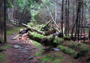
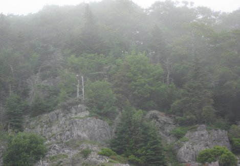
     We experienced terrain much like he describes on our visit to the Blagden Nature Preserve at Indian Point, pictured above.  The Nature Conservancy holds a strip of land that stretches past private properties down to Indian Point, an outcrop jutting into the Western bay that is home to the largest population of harbor seals north of Boston.  We went at high tide and couldn’t see the seals, but we could hear their grunting and jostling through the foggy bay waters.

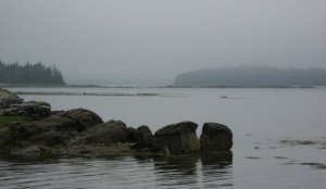
Indian Point, Mount Desert Island

Most of our time in the island’s interior was spent in Acadia National Park itself, which was founded by George Dorr with huge support from John D. Rockefeller, Jr.  Rockefeller loved designing and building roads and bridges, but he didn’t like automobiles much.  The covenant he set on the 47 miles of carriage roads he built and donated still protects the park today.

                     Acadia carriage_1_1                Acadia horseman_1_1

The carriage ride showed us 5 of the 14 stone bridges in the park.  Our driver was a horseman from Pennsylvania who uses these horses for logging in the winter and hauls eight of them to Acadia each summer for some productive exercise!

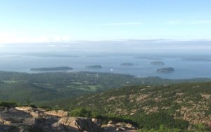
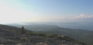
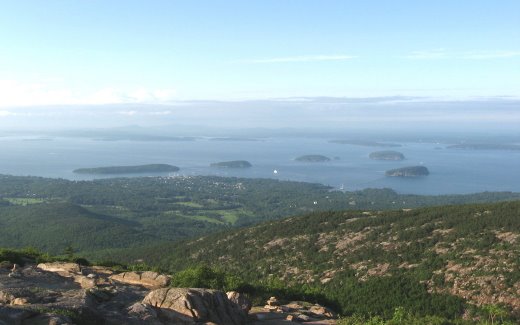
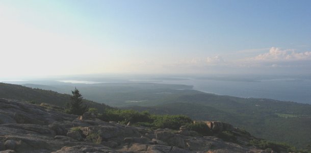
     We did use our car to travel to the top of Cadillac Mountain, the highest point on the huge, glacier-scraped slab of granite that is Mount Desert Island.  We caught a brief respite in the cloudy mists that enveloped us much of the week and were able to see upper Frenchman’s Bay, the location of our cottage, the town of Bar Harbor and it’s namesake island, whose sandbar constitutes an extension of Bridge Street, accessible on foot or by vehicle during low tides, and Otter Point, whose cliffs make the beautiful scene photographed by Cara below.

Cara and I are both point-n-shoot folks, but we both had some luck on this trip, displayed in the photo albums linked at the end of this post.  Below is my shot of upper Frenchman’s Bay.  The triangular protrusion just to the right of center is Sand Point, where we stayed.  We could walk at low tide and see all kinds of barnacles, clams and sometimes starfish.

  starfish by Cara_1_1  purple starfish by Cara_1_1 starfish in water by Cara_1_1

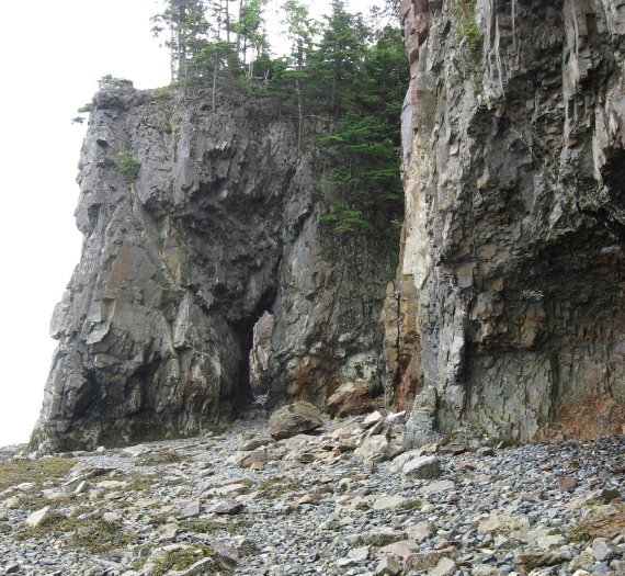
The geology available right below our cottage was also amazing.  We saw smaller versions of the caves and natural bridges to be seen on the bay islands from our nature cruise boat.

**************************
Mount Desert Rock, 25 miles out to sea

Mount Desert Rock, 25 miles out to sea

The two boat trips we took showed us no whales (thus the double trip) but lots of interesting sights and tales.  The official (and unsuccessful) whale watch took us all the way out to an amazing outpost on the continental shelf, Mount Desert Rock, whose intrepid lightkeepers maintained their residental post until the late sixties.  We saw lots of harbor seals and some gray seals there.  Our bonus nature cruise was just as foggy, but lightened by the salacious gossip of our nature guide, a grizzled native who had taught biology for 30 years but seemed much more interested in talking about the various owners of mainland and island properties than locating wildlife.   Bar Harbor history and the development and donation of Acadia represents a fascinating portrait of big money, monster money, and the economies of land use. Pre-income tax money built an large array of mansions, styled (50 room) “cottages” by their wealthy summer inhabitants, but almost all burned in a massive 1947 fire and were never re-built.  Modern billionares still have summer homes, but are likely to cooperate with the nature groups in maintaining the natural habitat around them.  Acadia, the first national park east of the Mississippi, was founded by George Dorr, a wealthy wilderness lover whose namesake mountain we half-climbed.  He, Rockefeller and others bought the many thousands of park acres one farm at a time.   The pristine, forested small islands we saw on this trip were bare, sheep-mown homesteads well into the twentieth century, and modern conservation acquisitions focus on these .  As commerce disappeared from the coastal waters and tourism rose as the leading industry, the island transformed from fishing and boat-building villages into Acadia-aligned restaurants, campgrounds, motels and services.  There are still plenty of boats and a healthy lobster fishery, which history we explored at a local nature museum and lobster hatchery.

pregnant lobster at Oceanarium

pregnant lobster at Oceanarium

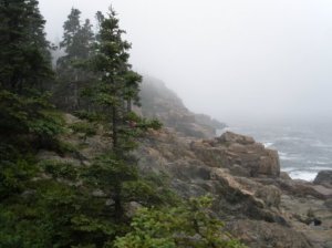
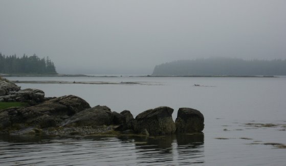
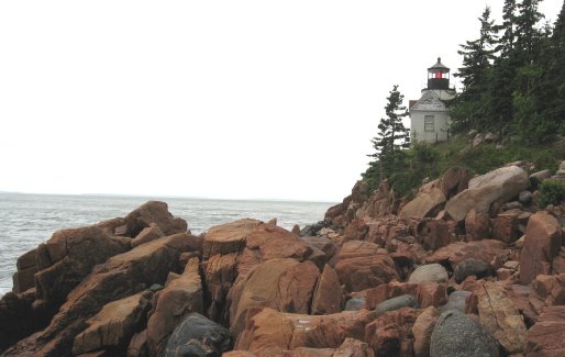
     The main respite we got from tourist crowds ourselves was on the state highways that follow the southwestern portion of the island.  Indian Point was off this road, and we found the prettiest rocky coast at the farthest tip of the island.  Bass Harbor and its historic lighthouse are shown below.

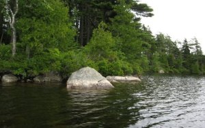
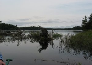
Mount Desert Island is a remnant of mountains that may have been as tall as the Alps, extending 80 miles beyond the current coastline.  The shore is built of granite and metamorphic materials carved and deposited by glaciers up to a mile thick.  The numerous bodies of freshwater are all long, narrow and aligned with the path of the glacier.  We canoed on Long Pond, one of these, and took the pictures below.

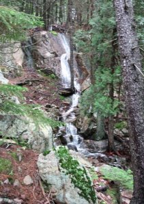
     Somes Sound is another of these long bodies of water but opens to the sea, splitting Mount Desert Island up the middle.  Somes Sound is the only fjord on the Atlantic coastline.  A waterfall that feeds it is shown below.

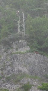
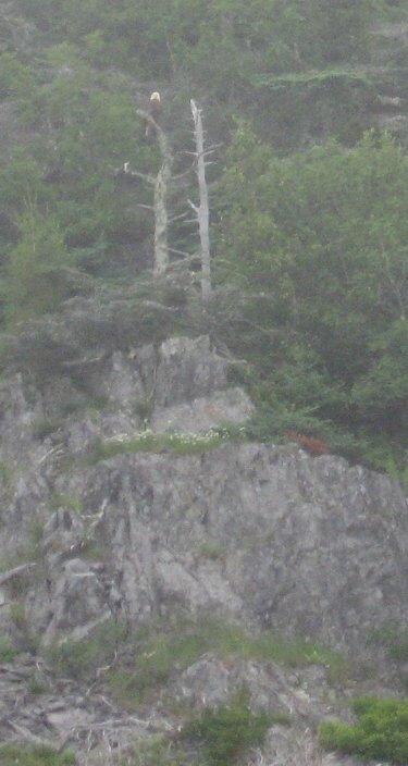
     The trip was adventurous and contemplative, invigorating and still soothing to our teacher souls.  I’ll end with one of the more thrilling sights – a bald eagle perched on the edge of an uninhabited island.  A close-up is at the top of the post.  Please do check the photo albums – many more beautiful sights of Maine.

Maine photo album Part One

Maine photo album Part Two

a wonderful professional set is at sueannhodges.com

*********************

     Who shall describe the inexpressible tenderness and immortal life of the grim forest, where Nature, though it be mid-winter, is ever in her spring, where the moss-grown and decaying trees are not old, but seem to enjoy a perpetual youth; and blissful,  innocent Nature,  like a serene infant , is too happy to make a noise, except by a few tinkling, lisping birds and trickling rills.     Thoreau,  Ktaadn

March 2, 2009

March Mad Beauty

snowy-oakwood-trees_1_1

   A late snow and a schoolday off to blog about it!  It didn’t take long to find a snow paradise.  The Oakwood Inn’s block sported the lacy treetops above.  But I was headed to the greenway.  I decided to check out an old favorite – the east end of Buckeye Trail.

   This wonderful view is the edge of the meadow at Buckeye Trail’s east end off Milburnie.  Down this oldest section of Raleigh’s greenways is a vista that provoked one of the first thoughts that originated this project – and it was a book project long before I ever knew what a blog was.  The scene used to look like a cathedral of treetops – but the loss of a huge red oak several years ago changed the look.  What’s left is seen below.

   The missing tree was on the right, and when it was there, I was ready to write a book partly to tell people to come here and take a deep breath.  It is still a very nice section of greenway.  I got to see the baby beeches of a couple of posts ago in a new light, literally.  The gentle snow provided a chance to see water moving across the greenway: in a freshet, and being blocked by the asphalt.  The creek was medium high, which I documented with a current shot of my favorite log-sitting spot.  Once I had done that, I knew I should head over to Hodge Road and take shots of my water level standard spots, which I’m documenting over on the nature projects blog.

snowy-landfill-meadow_1_1

The March snow was mighty pretty!

February 5, 2009

Midwinter Beech Luminaries

Filed under: Central Raleigh, Nature Lore — Tags: , , — raleighnaturalist @ 1:29 am

     At the easternmost tip of Raleigh’s greenways, Buckeye Trail at Milburnie Road, the young beeches, which keep their old leaves through the winter, look like luminaries spread through the flat lowland off this section of greenway. These pictures don’t really capture the effect – I’ll keep trying!

   This is close to the right time of day – right before dusk – and the dead of winter, but the eery quality involves the depth of their scattered penetration, evenly, through the slightly older but teenage pines…. and the perfectly flat lowland which nestles under Rollingwood where LongView Creek finds Crabtree.

     Midwinter is a great time to explore OFF the greenway, at least for poison ivy abhorrers like me.  The sewer cuts and fishing paths are available, and at this east end of Buckeye, the big beeches on the creek slopes have laid out startling off-white saplings to lighten up the dark winter texture of the woods.

December 14, 2008

Mistletoe Sightings

Filed under: Central Raleigh, East Raleigh, Nature Lore, Pecans & Mistletoe — Tags: , , — raleighnaturalist @ 8:19 pm
mistletoe-sign_1_1
     Mistletoe is common in the Southern Piedmont and has a strong herbal tradition as a medicine and as a holiday superstition and game.  This evergreen parasite is spread by bird defecation after eating mistletoe berries.  The latter link from the NC Museum of Natural Sciences tells us the name derives from the Anglo phrase for  “dung-on-a-twig.” Three different species have a complex role in all this.  The species most commonly used as decoration, phoradendron flavescens, is a native of North America. In California, it is considered a parasitic pest.  Viscus album is the European species whose berries are poisonous and also useful as medicine.  The species in my pictures is Phoradendron leucarpum, oak mistletoe, considered less common and rare in Europe, but apparently it is Raleigh’s most common, and the one favored by European Druids for its alliance with the mighty oak.
wade-ave-close-up_1_1
  
     Raleigh certainly has its share of oaks, and many of them in the area northwest of downtown sport the dusky green balls.  The spots inside the Beltline I best remember mistletoe are gone.  The planted median of Glenwood north of Peace Street used to have oaks that were full of prominent mistletoe, but I just today realized they have been replaced (quite some time ago – another geezer moment) with crepe myrtles, which are doubtless less trouble for the Progress Energy linemen.  But a large oak with a huge spread of mistletoe grows just across the street.  Mistletoe is not endangered: in fact I see it often in my travels, now that I have trained my eye to look for it.  But it does get harvested, and some  of what you see hanging in door jams is quite local indeed.
dans-mistletoe-stand_1_11
     Where do you get yours? Maybe from Dan, who was set up on Person Street as I drove out to take mistletoe pics for this post.  I explained our coincidence, bought a big branch and chatted about mistletoe.  I mentioned the old strategy I’d seen out at my country cousins of shooting it down with a shotgun.
     “Yeah, but that messes it all up.  I got this here the hard way – thirty feet up.”  From his yard, he said, but there is mistletoe in some public areas around town.  Does much inside the beltline get picked each year?  Wondering, I say goodbye to Dan and head out in search of unharvested mistletoe.  First stop is the most hilarious spot for mistletoe to hang: the corner of Cook and Oakwood.  The irony of this clump presiding over a corner where women of the street often hawk their sad-eyed wares in broad daylight is just too great for me to forbear mentioning.
Mistletoe at Oakwood Cemetery

Mistletoe at Oakwood Cemetery

     Heading out of downtown, I find nice groups at Harvey Street but none on Glenwood north of 5 Points.  Over on Wade, there are healthy stands at the SECU facility and on up that hill toward Oberlin.  The Canterbury/Banbury neighborhood has huge oaks, but many of them are Willow Oaks, and I saw almost no mistletoe there.  My schedule took me back toward home, and I saw the nice batches at the edge of Blount Street Commons.  This was a very partial and cursory inventory, but I plan to make this an annual post and develop a map of mistletoe sites in Raleigh (as I will for pecans, thus the name for my nature project blog).
****************
Suite101 Botanical info
***********
About.com’s mistletoe history
************
 
NC Farms Selling Organic & Low-Spray Christmas Trees and Wreaths (and Mistletoe)
************
Have a great holiday season!
 
« Newer PostsOlder Posts »

Create a free website or blog at WordPress.com.